
The Atlantic region is currently brimming with five tropical disturbances spanning the Atlantic Ocean, the Caribbean Sea, and the Gulf of Mexico. Currently, there’s no risk of any of these storms in Sebastian, Florida.
However, the National Hurricane Center (NHC) has advised residents of Florida to stay updated about these disturbances since their trajectories can shift.
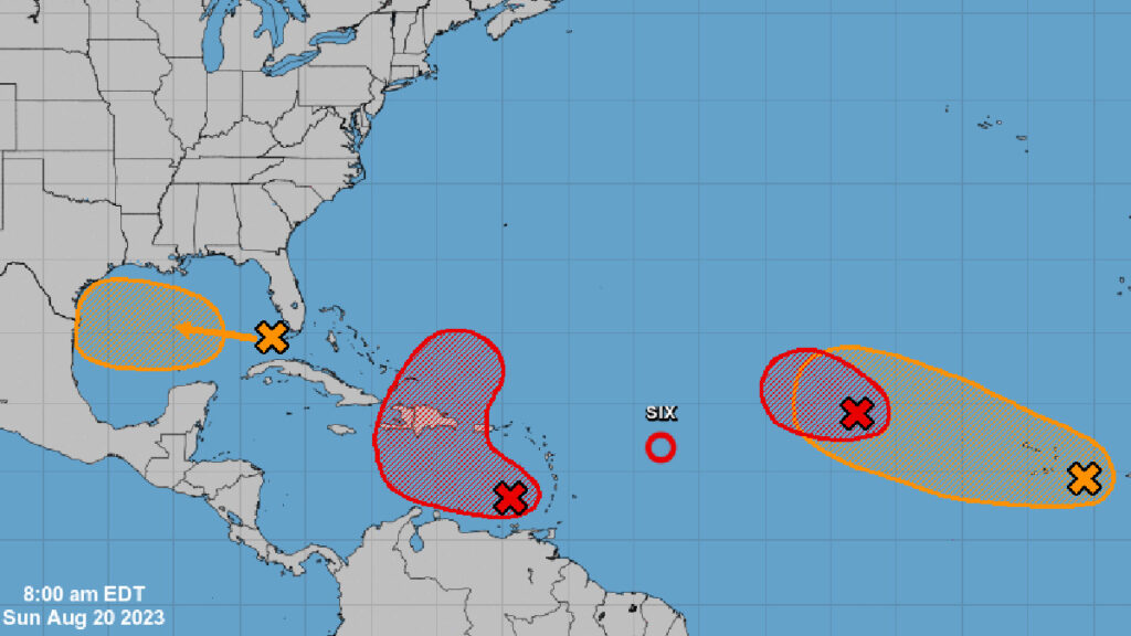
The NHC has released advisories concerning Tropical Depression Six, situated several hundred miles east of the northern Leeward Islands.
Central Tropical Atlantic (AL98)
Organizing showers and thunderstorms are observed in a low-pressure zone several hundred miles west-northwest from the Cabo Verde Islands. Satellite wind data showed the system generating up to 40 mph winds on its northern side.
NHC noted, “In addition, the first light visible satellite suggests the center may be becoming better defined. If these current trends continue, a short-lived tropical depression or tropical storm is likely to form later today or tonight while it moves west-northwestward at about 10 mph over the central tropical Atlantic.”
By the start of next week, stronger upper-level winds are predicted, which could hinder further development of the system. The system has an 80% formation likelihood over the upcoming week.
Eastern Caribbean (AL90)
A low-pressure area over the far eastern Caribbean Sea is exhibiting organizing showers and thunderstorms. This system will likely develop further, forming a tropical depression in the next few days. It is predicted to move west to west-northwest at speeds of 10 to 15 mph over the eastern and central Caribbean. By midweek, it should turn northward, moving into the southwestern Atlantic Ocean.
The NHC mentioned, “Regardless of development, heavy rainfall is possible over portions of the Lesser Antilles during the next couple of days. Interests in the eastern and central Caribbean should monitor the progress of this system. A NOAA Hurricane Reconnaissance mission is scheduled to investigate the system later today.”
It carries an 80% formation probability over the next week.
Western Gulf of Mexico
In the far eastern Gulf of Mexico, disturbed weather is anticipated to induce the creation of a broad low-pressure area soon. Slow development might occur as it progresses westward at about 15 to 20 mph, potentially forming a tropical depression by Tuesday as it nears the western Gulf of Mexico coast.
Its formation likelihood over the upcoming week stands at 50%.
Eastern Tropical Atlantic
A vast area of disorganized rain and storms over the far eastern tropical Atlantic is linked to a tropical wave.
The NHC commented, “Environmental conditions appear conducive to the gradual development of this system, and a tropical depression could form later this week while it moves west-northwestward across the eastern tropical Atlantic.”
It has a 50% chance of developing in the subsequent week.
Weather in Sebastian
Sebastian will experience cooler temperatures, about 5 to 7 degrees less than the previous fortnight, with highs hovering around 88 degrees and nighttime lows approximately 77 degrees.
Rain probability is down to 30% daily. Windy conditions are expected throughout the week, primarily coming from the Northeast at speeds of 10 to 15 mph.

